Situational Awareness – An editorial opinion
By Clay Lacy in January 2001 Professional Pilot Magazine’s “Situational Awareness”
ATP/CFII/Helo/Sea.
Boeing 747, Gulfstream II/III/IV,
Hawkers, Learjets, Citations and
25 misc type ratings
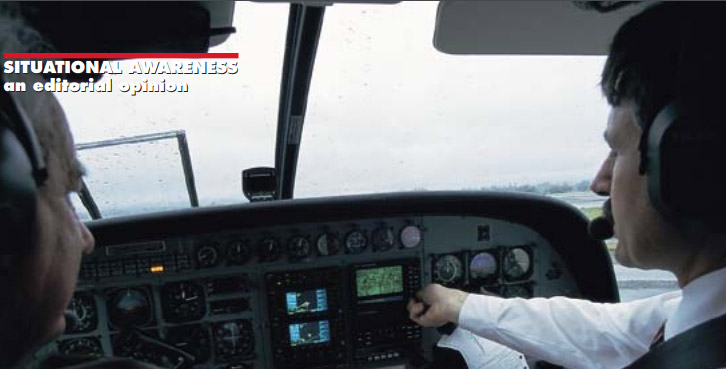
During a Pro Pilot flight test aboard a Cessna 208B Grand Caravan, Pilot-Author Clay Lacy (L) and Cessna Mgr ATD Fleet Ops Gregory Parlish input flight information to an Avidyne FlightMax 740 MFD. The FlightMax 740 displays a moving map and IFR and VFR charts, and interfaces with the Ryan TCAD for collision avoidance and BFG Stormscope for lightning presentation. Next to the FlightMax are 2 Garmin GNS430 GPS nav moving map displays.
While situational awareness is often associated with controlled flight into terrain (CFIT), I think it has a much broader meaning. As far as I’m concerned, situational awareness is knowing everything that can affect your flight. A pilot with good situational awareness, in my opinion, will never have a real emergency, as he is totally prepared to handle any situation without going into overload.
Advances in flightdeck technology and avionics are taking us into an era where flying IFR will become essentially the same as flying VFR. Within 10 years we’re likely to have flightdeck presentations that can synthetically simulate looking out of the window on a severe clear VFR day. While current flightdeck technology—including GPS, moving map displays, head-up displays (HUDs), EGPWS and TCAS II—is wonderful stuff, it’s only the beginning.
I see the day when this is all integrated, intuitive and seamless, to the point that we’ll be able to see the “real world” via synthetic vision and enhanced vision technology no matter what the weather conditions. However, while we move toward a fully synthetic situation, we’re still in something of a “Twilight Zone” transition phase. While the requirement to be a good hands- on pilot is becoming less and less important these days with our modern automated flightdeck systems, we’re not at the point yet where automation is relegating pilots to more of an observer role.
A pilot who wants to live a long time still needs to have good situational awareness. This includes always knowing exactly where you are, where the nearest suitable airport is in case of a serious emergency, and where you are in relation to terrain.
A pilot should give his total attention to flying at all times. Preplanning, thinking ahead and always being ahead of the airplane are a must. It is never just a single mistake that causes an accident—it’s always several mistakes that allow the airplane to catch up and pass the pilot, creating real potential for an accident.
Honeywell’s flight situational display (FSD) contains the primary flight display (PFD) of attitude, airspeed, altitude and navigation information plus TCAS display with superimposed weather radar, thrust setting indicator and 3D symbology with terrain avoidance data. Photo courtesy Honeywell
SITUATIONAL AWARENESS EVOLUTION
Before World War II, pilots were taught to fly VFR and they flew dead reckoning compass headings with maps on their laps. They’d look for landmarks such as rivers, towns and railway tracks, while also noting fields they could deadstick into if needed. This was good consistent situational awareness.
As the transition to instrument flying took place, pilots started flying “thinking numbers” like heading, low frequency range leg courses, and they did not always keep the big picture—north, south, east and west of the airport or terrain—in their minds. A lot of accidents happened in the 1940s and 1950s due to disorientation.
The best pilots, then and today, always have a mental picture—just like flying VFR—while they’re in the clouds flying IFR. If you as a pilot keep that picture going, you won’t get disoriented.
While flying long range over water, at each waypoint I always set the heading bug for heading to next way- point. Flightplans are so good these days headings seldom vary from plan by more than 2 or 3 degrees, and if they do you just need to go to heading mode on autopilot to stay near course while you figure it out.
The next phase in flightdeck evolution—flight management systems (FMSs) and horizontal situation indicator (HSIs), with vectors and waypoint displays—were, and are, great tools as long as you put the right information into them. But even with these advanced systems, it is critical to maintain good situational awareness. The well publicized American Airlines accident near Cali, Colombia, where the wrong waypoint was entered into the FMS, leading to a crash into the side of a mountain, is a classic example of what can go wrong when you lose situational awareness and either do not know or do not fly published headings.
GPS-based moving map technology has been one of the greatest advances ever in terms of pilot situational awareness. You can see your aircraft superimposed over the real world, and you always know where you are in relation to topography, cities and airports. This puts us back, in some degree, to the pre-WWII days when pilots flew VFR looking out of the window. Low cost panel mount moving map displays, such as Avidyne and Garmin products, have become a great aid in maintaining pilot situational awareness. And they’ve become affordable even for pilots of smaller general aviation aircraft.
Enhanced vision system (EVS) technology will build on moving map capabilities. With EVS the flightcrew gets a “real” view of runway and terminal areas via FLIR, millimeter wave radar and other sensors. One day we’ll be making all our approaches essentially VFR no matter what the visibility conditions. As airborne computer capability has become more powerful, with avail- able memory to store entire world databases, we now have EGPWS and TAWS (terrain awareness and warning system) to take us yet another step toward future synthetic vision possibilities. Universal Avionics’ new TAWS has such good fidelity and realism that a pilot can fly up a canyon in weather just by using the TAWS display. I’m told, however, that FAA made them downgrade the display prior to certification because it felt it was just too good—and was afraid pilots would use it in place of other IFR instrumentation.
This Universal Avionics Vision 1 EFI890 PFD is a synthetic vision and display system which represents the next step in augmented situational awareness beyond UNC’s recently certified terrain awareness and warning system (TAWS). Photo courtesy Universal Avionics
Here is a real time image transmitted from an IR camera mounted in the nose of a Gulfstream V to the HUD on the flightdeck. Gulfstream is offering the Kollsman EVS married to a Flight Dynamics head-up display system (HGS). Photo by Jose Vasquez
Today, Universal Avionics, along with Honeywell, Rockwell Collins and BFGoodrich, are moving ahead with practical and affordable synthetic vision flightdeck technology. At NBAA I had a chance to look at Universal’s concept for a synthetic vision display system—Vision 1. It’s the next generation beyond TAWS and consists of a primary display, terrain database and high-speed computer, which replace traditional flight instruments with a synthetic overlay of the terrain ahead. Assuming that this technology is FAA certified, pilots will have a flightdeck display which realistically simulates looking out of the window on a VFR day. Eventually, this format will portray your course as well as synthetic indicators of runways and obstacles. Situational awareness will become less of a factor because you can easily look down, or up to an HUD, and see exactly where you are.
When you can see where you are at all times, you solve most of the situational awareness problem. The outside view may be synthetically generated or in real view, as with EVS, but the end result is that IFR flying will be as easy and as safe as flying VFR.
SAFER PILOTS
Future lower-time pilots will have better situational awareness than they have today, thanks to forward leaps in new flightdeck technology. In terms of classic situational awareness—knowing where you are—the issue will hardly exist in the future with all the new equipment that’s coming out. These days, pilots no longer need 10,000 hrs to be considered experienced pilots. A person who really thinks about flying, and who strives to increase his or her knowledge and skills, is probably as good as he or she is ever going to be at 3000 to 5000 hrs TT. In the future, with the help of situational awareness boosting technologies, we’ll probably find 2000 hrs experience is plenty in order to be as safe as a much higher experience level pilot is today.
I do not see automated, pilotless airplanes in the foreseeable future. And I believe we’re a long way from having airplanes where you can check someone out like you do in a car. Over the next 20 years I don’t believe you’re going to see any system in a small jet where you can take a 60-hr private pilot, put them in and have them operate it safely. And it’s not likely that there will be technology over the next 20 years that can substitute for experience and tell you to fly around a thunderstorm and not through it. It’s going to be a long time, in my opinion, before we reach a point where pilot experience is no longer necessary.
With advances in HUD technology, and implementation of large flat-panel head-down displays, you’ll be able to comprehend the big picture better and fly safer. We can expect more automation in the flying process, as well as a migration of the ATC function from controllers on the ground to airborne systems. While TCAS II is a great device, I can envision a next-generation system that’s hooked up to the autopilot and autothrottles and that will change course on its own to avoid a collision. With an autopilot link, the airplane could move up or down 200 ft and then be put it back on course and attitude.
With the accuracy provided by GPS, not only are we not going to need as many ground-based air traffic controllers, but we may no longer need VORs. If FAA were to shut down all the VORs, with the exception of some in terminal areas, they wouldn’t have to maintain and inspect them, and they’d probably save enough money in the 1st year alone to give every air- plane in the sky 2 GPSs.
Rockwell Collins Pro Line 21 avionics system can blend sky/ground imaging. Based on mechanical representations with high resolution graphics, it incorporates synthetic terrain maps to give pilot position al knowledge regardless of actual visibility conditions. Photo courtesy Rockwell Collins
I believe airspace can be used much more effectively than we are using it today. VNY (Van Nuys CA), for example, is one of the busiest airports in the country, yet the greatest number of airplanes I’ve ever been able to count in the local skies at any time is 15. Now, in my opinion, that’s not a case of crowded skies. If you look at the Interstate 405 and 101 freeways just to the east of the airport, there are thousands of cars running around on the ground. Somehow we have to figure out better ways to use our skies. Each aircraft should not have to take up a square mile of airspace 1000 ft deep. If all aircraft had some sort of device to maintain their own separation, rather than controlling them from the ground, we’d be able to put a lot more aircraft in the same airspace, and do it safely. Here again, GPS applications, being as precise as they are, will go a long way toward developing a future aircraft-based ATC system.
SURFACE SITUATIONAL AWARENESS
An important situational issue has to do with surface guidance and ground operations. This is evidenced by a number of recent ground incursions, including the recent Singapore Airlines accident at TPE (Taipei, Taiwan). Among the problems we have at major airports are aircraft crossing the wrong runways, not holding short and attempting to take off on closed runways. I feel there are some real strides that can be made in improving surface guidance and situational awareness. Honeywell is taking an industry lead in developing all- weather surface guidance systems to give both pilot and controllers a synthetic or enhanced view of the airport area. Such systems will greatly improve situational awareness on the ground, avert runway incursions and reduce the chance of takeoffs on closed runways while allowing ground movements to keep up a better pace in low-vis conditions.
THE NEXT LEVEL
With GPS, HUD, moving map displays, TCAS II, EGPWS and the prospect of synthetic vision systems just over the horizon, we’re flying safer these days. And we now have a much clearer and more intuitive idea of here we are in relation to topography, weather and traffic. However, we still have a long way to go in terms of integrating all of this technology.
BFGoodrich Skywatch traffic advisory system uses TCAS-like symbology to display transponder-equipped aircraft in either a selectable 2 or 6-nm range. Information displayed includes range, bearing, relative altitude and vertical speed/direction. Photo courtesy BFGoodrich
UPS Apollo MX20 MFD shows various types of information, such as flightplan, moving map, terrain and traffic advisories, on a 6-in (diagonal) CRT. Single, multiple and combined color images can be displayed. Each data type can be turned on or off individually using menu toggles and various combinations can also be displayed. UPS MX20 received high marks in recent Capstone tests in Alaska.
Highway-in-the-sky concepts, complete with synthetic and enhanced vision attributes, will allow a future generation of pilots to fly safer and with much improved situational awareness. Replacing ground ATC functions with airborne-based controls on airplanes will permit us to use our airspace much more efficiently and with greater margins of safety. I also envision the pilot training function changing somewhat because we’re reaching the point where a pilot will no longer need to be a really proficient instrument pilot. With synthetic and enhanced vision displays in the flightdeck, there will be little noticeable transition from VFR to IFR flying. However, despite the wonders of flightdeck automation, pilots will still remain in command of their aircraft, and firmly planted in the loop. Adequate training to use the new equipment properly will be a must.
At some point, I suppose, it may be practical to have fully interactive man/machine flightdecks—perhaps something along the lines of the overprotective computer system named HAL in Stanley Kubrick’s movie 2001: A Space Odyssey. Highly automated flightdeck systems, possibly with artificial intelligence and self-healing electronics, may have the computer making recommendations to the pilot on course variations and routings, and these systems may eventually take over much of the traditional pilot decision process. Maybe I’m old- fashioned, and I’m sure in some ways I am, but I believe there will always be a place for a well-trained, situationally aware pilot in the flightdeck.
Clay Lacy has more than 50,000 hrs of flying experience in everything from DC3s to Boeing 747-400s and nearly every type of corporate aircraft. His VNY-based Clay Lacy Aviation is home for Lacy’s popular charter fleet, which includes everything from Learjet 24s up through a G550 and Boeing Business Jets.